FieldTwin GIS data handling and Public Data Sources
As a user in FT you can choose to add a WMS or an ARCGIS Map server as a layer in your project. You can have multiple sources at the same time with different services. to use map services in FT you need to set up a CRS in the project settings.
Using WMS, all Web Map Services has a list of published CRS's, if the CRS set in the project settings is not a part of the list in the web map services, we don't allow the map data to be created.
Using ArcGIS map server, we query the data from the server to the set project CRS (EPSG code), and the Arcgis map server does the transformation of the data for us before we show it as a layer or you can choose to import geometry from it using the rules engine
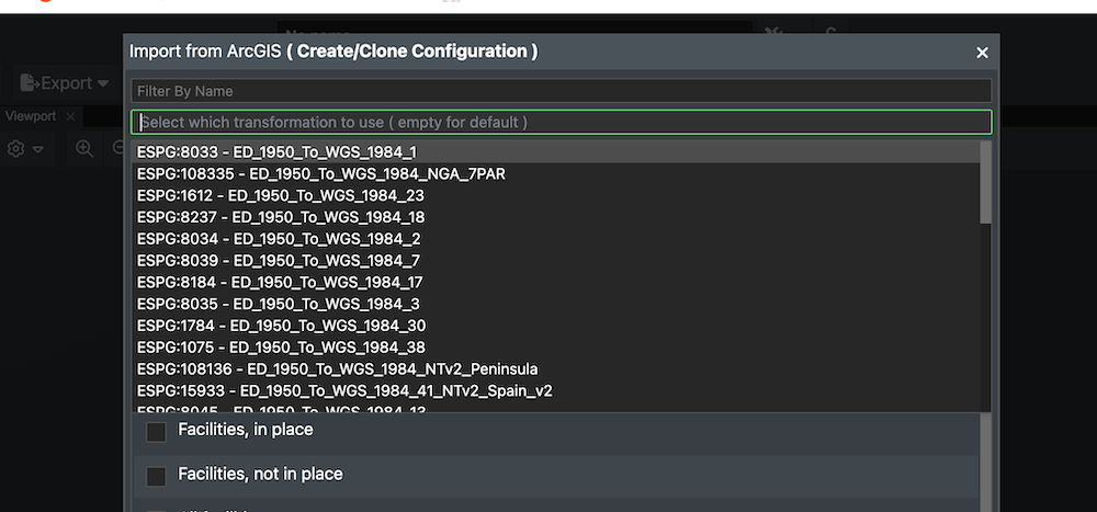
Transformations can also be handled manually if the ARGIS Server has a list of possible transformations available. Then a dialog box will appear in this case so the user can select the correct transformation method.
If you want to import geometry from a WFS, all WFS has a list of published CRS's, if the CRS in the project settings is not in this list, then we do the projection of the data on import
GIS data handling
We use Proj for handling our projections.PROJ is a generic coordinate transformation software that transforms geospatial coordinates from one coordinate reference system (CRS) to another. This includes cartographic projections as well as geodetic transformations.
Coordinate reference systems
ESPG.IO
ESPG simplifies discovery of coordinate reference systems utilised all over the world for creating maps and geodata and for identifying geo-position. It is a practical tool for anybody interested in cartography and digital map making, who needs to know exact latitude and longitude values for numerical coordinates in different spatial reference systems. Included map application allows to show the precise location anywhere on the planet also visually.
All the coordinate system definitions come from ESPG.IO (you can get it directly with https://epsg.io/[EPSG], so for example NAD50 UTM32 would be : https://epsg.io/23032, and the description we are using : https://epsg.io/23032.proj4 )
The value we get for EPSG:23032 is :
+proj=utm +zone=32 +ellps=intl +towgs84=-87,-98,-121,0,0,0,0 +units=m +no_defs
This gives Proj4 the information it needs for the conversion :
+proj, projection type : UTM (which gives the method for converting the coordinate from cartesian to geocentric ).
+ellps, the ellipsoid used (intl here, for international, Hayford).
+towgs84, the datum shift; to convert the computed geocentric coordinate to wgs84.
+units the unit the coordinate are in (here in meters)
+no_defs, just tell proj4 to not use default values, and use the ones we provided.
For a deeper explanation of these parameters please go to: Proj General Parameters
Understanding WGS84 and EPSG:3857
The world of geospatial data relies on accurate coordinate systems to define locations. While a widely recognized standard exists, it's crucial to understand the nuances of different systems to ensure the accuracy of your projects.
WGS84 (EPSG:4326): The Geographic Standard
- WGS84 (World Geodetic System 1984) is the modern standard geodetic datum that defines the Earth's size and shape.
- It underpins the Geographic Coordinate System (EPSG:4326), which uses Latitude and Longitude to define a 3D position on the Earth's surface (the ellipsoid).
- This is the system used by GPS and GNSS devices and for storing data in most geospatial databases.
EPSG:3857: The Web Mapping Standard
- EPSG:3857 is the code for the Web Mercator (or Spherical Mercator) Projected Coordinate System.
- It is based on the WGS84 datum but is a 2D projection used almost exclusively by major web mapping services (Google Maps, OpenStreetMap) because it keeps map tiles square and speeds up rendering.
- Crucially, it is not an official global coordinate system for precise measurements due to its severe scale distortion.
Importance of Local Coordinate Systems for Precision
While EPSG:3857 (Web Mercator) is globally recognized, it is not always the most practical or accurate choice for measurements, particularly for engineering or surveying projects that require high precision.
-
Distortion and Inaccuracy in EPSG:3857 Web Mercator
- All projected systems cause distortion, but EPSG:3857 is particularly problematic. It severely exaggerates scale as you move further north or south from the equator.
- For a project located far from the equator, 2D measurements taken in EPSG:3857 will be significantly longer than the true ground distance. The distortion is severe enough that EPSG:3857 should be avoided entirely for projects where measurement accuracy is critical.
-
Minimizing Distortion with Local Systems
- Local or Project-Specific Projected Coordinate Systems (such as UTM Zones or State Plane Systems) are designed to minimize distortion over a specific, smaller area.
- They typically apply a small-scale factor to the map projection, ensuring that planar (2D) measurements closely match the true ground distance.
-
Measurement Error Example
- As an example a pipeline of 5000 m measured in a high-accuracy system like UTM Zone 31N would be approximately 5000 m.
- The same pipeline measured in EPSG:3857 (Web Mercator) would be longer due to distortion. Depending on the latitude, the error is typically in the range of 10% to 30%.
Best Practice for FieldTwin and Geospatial Projects
To achieve the highest possible accuracy for planar (2D) measurements, always select a coordinate system optimized for your project location.
-
Avoid EPSG:3857 (Web Mercator) for Precision
- Because planar (2D) measurements in FieldTwin do not account for the Earth's curvature, using EPSG:3857 will lead to significant inaccuracies, especially far from the equator.
-
Select a Local Projected Coordinate System
- FieldTwin's support for the EPSG dataset allows users to select an appropriate Coordinate Reference System (CRS).
- We strongly advise against using EPSG:3857 when precision is critical. Instead, users should opt for a local or project-specific system (like a specific UTM Zone) that is designed to minimize distortion and improve measurement accuracy in the project's area.
Public Data Sources
There are several government or other public data sources that provide open and free to use map and bathymetry data that can be useful for your Field Development projects. As FieldTwin allows you to connect to WMS (Web Mapping Services) and WFS (Web Feature) and ArcGIS services these data sources are easy to use to enrich your field layout. You can also find free Bathymetry data around the world accessible in the same fashion.
Note! This list is provided as is and FutureOn is in no way responsible for the content, use, data or it's accuracy so please read the site disclaimers for any copyright or accuracy information.
Web Mapping Services (WMS)
The use of geography data is becoming more and more important for Energy operators and service providers to make informed decisions. This can be in terms of locating and extracting new resources, better field design and planning, information retrieval and offers deeper insight into relationships and patterns as part of everyday operations. You can add a map layer to FieldTwin Design using the WMS (Web Mapping Service) to Add a WMS Layer.
ArcGIS REST Services
ESRI provides open data through their arcgisonline services using their REST API. You can see what is available here ArcGIS REST Services. You can add a ArcGIS map layer to FieldTwin using the ArcGIS option in the Create Menu for ArcGIS.
As an example, this is the REST API URL for the World Imagery Map service:
http://services.arcgisonline.com/arcgis/rest/services/World_Imagery/MapServer
With this URL, you will then get the following Map layer in FieldTwin Design as shown below:
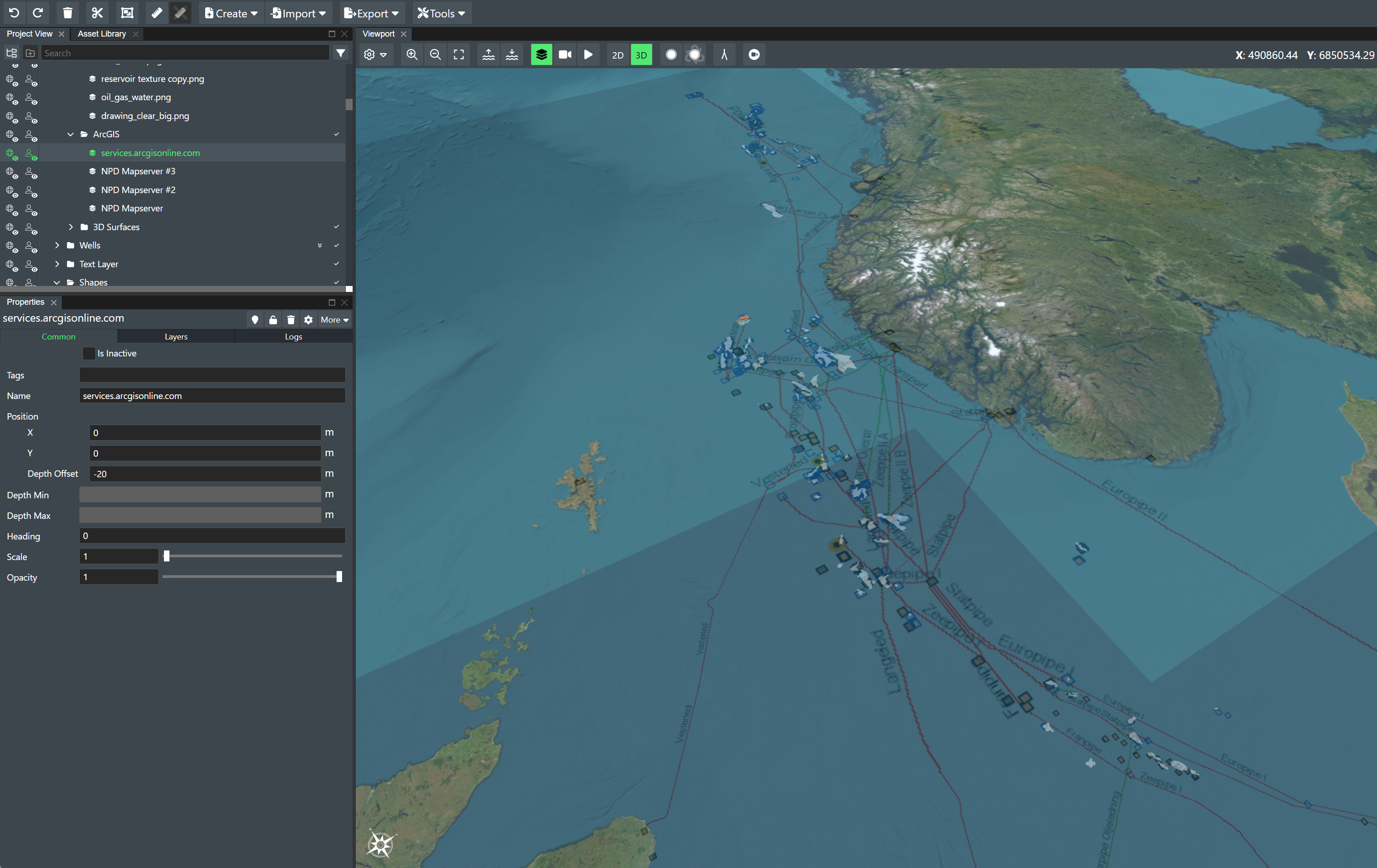
Norwegian Offshore Directorate
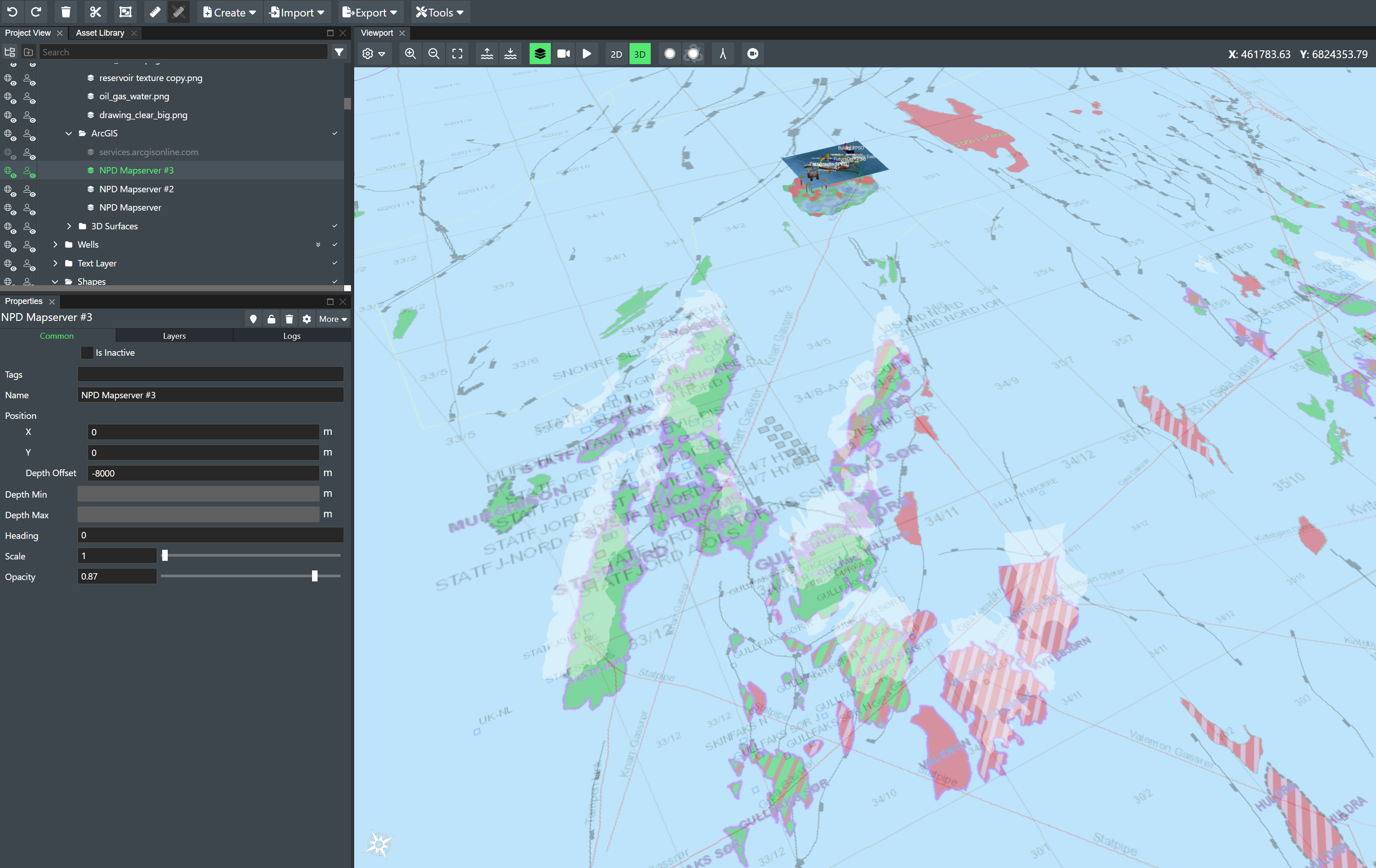
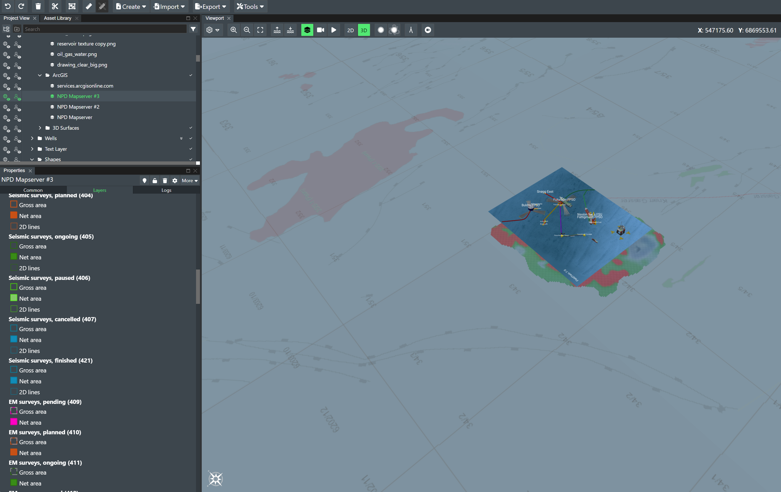
If you are working on project on the Norwegian continental shelf you can now access the Norwegian Offshore Directorate open map service and visualise information such as well-bores, surveys, fields and discoveries, production licenses, agreement-based areas, permanent facilities and more as part of your layout to facilitate more effective discussions for e.g. equipment and piping scenarios.
In your project settings under Map Settings select the following Coordinate Reference System EPSG:23031 - ED50 / UTM zone 31N, and then select the following menu item Create -> ArcGIS and input this URL:
https://factmaps.sodir.no/arcgis/rest/services/FactMaps/3_0/MapServer
With this URL, you will then get the following Map layer in FieldTwin Design as shown below:
GeoNorge
Geonorge is the national website for map data and other location information in Norway. Users of map data can search for any such information available and access it here.
WFS
FieldTwin Design supports direct import from WFS (read: Web Feature Service) mapping servers/services such as e.g. ArcGIS. This means you can directly import Web Mapping Features as vector data e.g. existing pipeline data as new connections in FT Design. Read more about Using WFS
NOD
If you are working on project on the Norwegian continental shelf you can now access the Norwegian Offshore Directorate Open Map service and visualise information such as pipelines.
They provide the following map services:
As an example, this is the WFS URL for the NOD map service:
https://factmaps.sodir.no/arcgis/services/FactMaps_ogc/3_0_ED50_z32/MapServer/WFSServer?request=GetCapabilities&service=WFS
Bathymetry
FieldTwin Design is able to ingest bathymetry as x,y,z data (pointclouds) or as GeoTIFF files. FutureOn has used the GeoTIFF datasets from the following providers below successfully. Read more information about loading 3D surface. Note! The right CRS (Coordinate Reference System) has to be defined in the project settings. See General Settings.
Bathymetry can also be imported from Arcgis online, more information can be found here.
EMODnet
Gebco 2020 Gridded Bathymetry Data Download
Please read the terms of use below!
Ocean Data Platform
Empowering ocean insights with a cloud-based geospatial platform. Seamlessly access rich and structured ocean data from public and private sources. Unlock powerful analysis tools through an intuitive workspace, flexible API, and Python SDK. Designed for interoperability in a federated ocean data ecosystem. Read more about Hub Ocean